April
It is a great time of year for portraits. I have times available so please call the studio number and leave a message and I will return your call as soon as possible.
Seniors
Time to order your Graduation Announcement Cards

What we have
once enjoyed we
can never lose;
All that we
love deeply,
becomes a part of us.
~Helen Keller

Bridgette
Elizabeth
Twining
March 22, 1993
September 3, 2011
Maps
- Carver
- Landscape Arboretum
- Mississippi Trail/Warehouse District
- Murphy’s Landing
- Wayzata Beach
- Lake Riley
Historic Carver
Historic Carver Minnesota is located just 25 short minutes from down town Minneapolis.
Directions from Highway 494 | Crosstown Highway 62 | Highway 169
Take Highway 212 west and exit on Highway 41/Chestnut Street. Turn left and travel two miles to Chaska Boulevard. Turn right on Chaska Boulevard. Go one mile and take a slight left onto County Road 40. Follow County Road 40 into Carver. Take a left on Broadway Street (CR 40). Travel one block and park in the street. I will meet you on the corner of Broadway Street and 3rd Street East. You will see Harvey's Bar on the corner.
Map your route to Historic Carver
Click HERE to map your route to the Historic Carver.
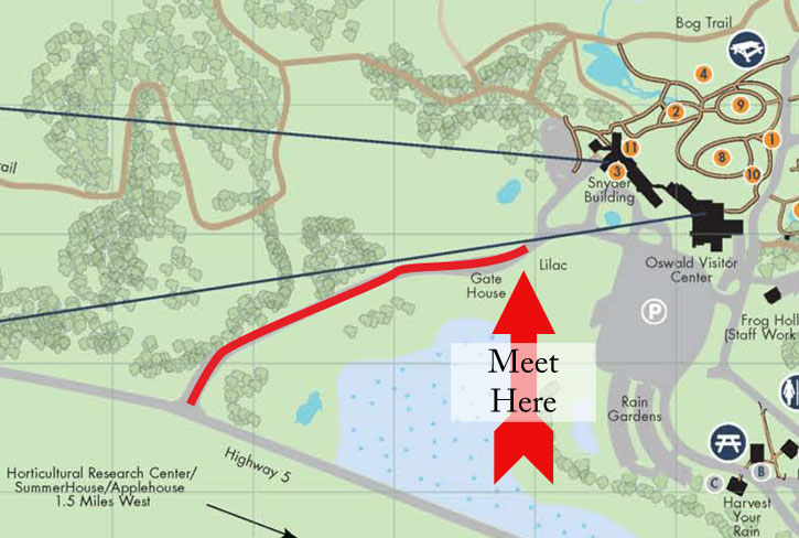
Landscape Arboretum
Important information on this page - please print out.
The Minnesota Landscape Arboretum is located on the southwest corner of Highway 5 and Highway 41 in Chaska Minnesota.
- Admission tickets will be emailed to you. The first ticket is for your photographer and the remaing tickets are for your group.
You may print out the tickets or you may show them to the gard from your phone.You will not be charged admission. - Pull forward and park to the right.
- Your photographer will meet you next to the gate house. If you do not see us right away, we will be with you shortly - we may be finishing a session.
If you have any questions regarding the weather, please call the studio two hours before our session. If you become lost or are running late, please call the studio cell phone at 612-599-2203.
Pets are not allowed at the Arboretum.
Map your route to the Arboretum
Click HERE to map your route to the Landscape Arboretum.
The Warehouse District and The Mississippi Trail
Important information on this page - please print out.
The Warehouse District and the Mississippi Trail sessions meet on Nicolet Island in downtown Minneapolis. We will meet you at the parking lot on the corner of Wilder St. and Merrian Rd. You will see the Nicollet Island Inn accross the street. We will then go from there to your session.
Please arrive on time. If you do not see your photographer as soon as you arrive - do not worry, they will be with you shortly.
If you have any questions regarding the weather, please call the studio two hours before your session.
If you become lost or are running late, please call the studio cell phone at 612-599-2203.
Map your route to the Mississippi Trail and Warehouse District meeting location
Click HERE to map your route.
Murphy’s Landing (The Landing)
Important information on this page - please print out.
Historic Murphy's Landing (The Landing) is located approximately 23 miles southwest of Minneapolis at 2187 East Highway 101 in Shakopee.
From Minneapolis, take Interstate 394 west, turn south on U.S. Highway 169 and take Highway 101 west approximately four miles to the Historic Murphy's Landing (The Landing) entrance, which is located on the north side of the highway, just west of Valleyfair Amusement Park. Use the WEST entrance
When you arrive at the Murphy's Landing (The Landing), we will meet you in the parking lot.
The welcome center has rest rooms. We suggest that you arrive a few minutes
early if you will need to use the facilities.
If you have any questions regarding the weather, please call the studio two hours before your session.
If you become lost or are running late, please call the studio cell phone at 612-599-2203.
Pets are not allowed at Murphy’s Landing.
Map your route to the Murphy's Landing (The Landing)
Click HERE to map your route.
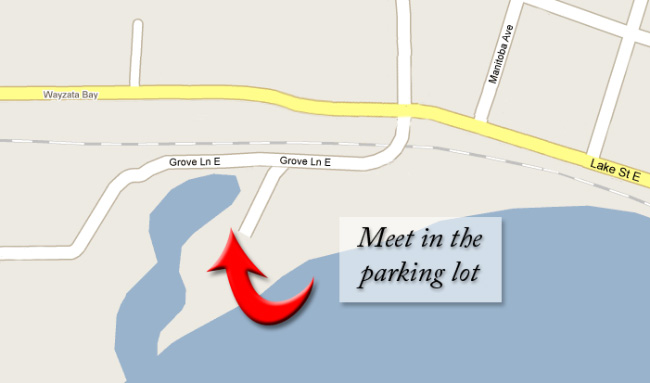
Wayzata Beach
Important information on this page - please print out.
Wayzata Beach is located in Wayzata on Grove Lane E just off of Lake Street.
We will meet in the parking lot near the beach.
Please arrive on time. If you do not see your photographer as soon as you arrive - do not worry, they will be with you shortly.
If you have any questions regarding the weather, please call the studio two hours before your session.
If you become lost or are running late, please call the studio cell phone at 612-599-2203.
Map your route to the Wayzata Beach
Click HERE to map your route.
Lake Riley Park
Important information on this page - please print out.
Lake Riley Park sessions meet in the parking lot next to the playground and pavilion.
Please arrive on time. If you do not see your photographer as soon as you arrive - do not worry, they will be with you shortly.
If you have any questions regarding the weather, please call the studio two hours before your session.
If you become lost or are running late, please call the studio cell phone at 612-599-2203.
Map your route to Riley Lake Park meeting location
Click HERE to map your route.
find us on Facebook!